Smoke Locate
Authors: Matt Johnson
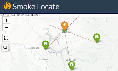
Abstract: In an emergency, rapidly identifying the location of a fire is critical. With this application a user selects 2 or more towers on the map. The intersection of lines drawn from each tower at the given bearing indicates the location of the smoke.
Full Description: In the Australian state of Victoria on a hot, dry summer day fire can spread at up to 10 km/h in forest and up to 20 km/h in grassland. The timeliness of the initial response to a fire is critical to containment and reducing the severity and impact of the fire.
Victoria has a network of almost 90 active fire watch towers. When smoke is sighted, these towers use a triangulation method to narrow in on the exact location.
With this application a user selects 2 or more towers on the map. The intersection of lines drawn from each tower at the given bearing indicates the location of the smoke.
This digital process is intended to replicate and simplify the manual triangulation process, while at the same time incorporate modern reverse geocoding capabilities that can convert a location into an address.
Smoke Locate is intended to be as simple to use as possible and is designed to be usable on small screens, such as phones and tablets, that may be in field operation.
While this project is made for the state of Victoria in Australia, it can be modified to suite any area. The only requirement to modify this app is network of towers or observation points. And observation points can be generated dynamically within the application.
Matching an address or location to coordinates is done using the open source
Open Street Map (OSM) Nominatim API
made available via the tmaptools R package.
All data used on this application is openly available via the links below:
- Tower location and names are sourced from the
Geomark Point
data set which contains the named locations of topographic features. - Current fire incidents and burn areas are sourced from a geojson hosted on Victoria's
Emergency Portal. - Victoria's Country Fire Authority (CFA)
Total Fire Ban Districts (TFB)
are part of the Victorian governments Vicmap Admin series which contains administrative boundaries.
All code for this application is available on Github
If you experience errors or wish to suggest improvements, please submit a
Github Issue.
Keywords: emergency,fire,triangulation,smoke,location,leaflet,sf
Shiny app: https://mrjoh3.shinyapps.io/trilocate/
Repo: GitHub - mrjoh3/trilocate: In an emergency, rapidly identifying the location of a fire is critical. With this application a user selects 2 or more towers on the map. The intersection of lines drawn from each tower at the given bearing indicates the location of the smoke.
RStudio Cloud: Posit Cloud
Thumbnail:

Full image: