Thank you for your reply. I include here more info about my problem. A minimal Reproducible example.
**library**(ggplot2)
**library**(tspmeta)

coord=read.csv2("CoordinatesUKExample.txt")
coords.df=data.frame(long=coord$Longitude,lat=coord$Latitude)
coords.mx=as.matrix(coords.df)
dist.mx=dist(coords.df)
tsp.ins <-tsp_instance(coords.mx,dist.mx)
tour=run_solver(tsp.ins,method="2-opt")
autoplot(tsp.ins,tour)
head(coord)
#> Postcode         	 City			 Latitude 	 Longitude
#> 1 AB53 8BJ 	     	Aberdeenshire   57.52995 	-2.4509960
#> 2 NE46 4SA         	Acomb 			54.99080 	-2.1184036
#> 3 NE66 2HT       	Alnwick 		55.39723 	-1.6900000
#> 4 CA16 6QR       	Appleby 		54.57808 	-2.4929927
#> 5 CA16 6JP       	Appleby 		54.60883 	-2.5188636
#> 6  CO7 7LG       	Ardeigh 		51.92808     0.9833302
In that case this is the optimal path to include all the points. But What I am looking for is to calculate the points that are near to a main route between two cities (points).
I have made also this to map the points in the UK and make it easier to understand. I have calculated all the geodistances between the points and create clusters regarding that distances just to show points in the map (now there are only 10 cities but in the real case I have around 80):
**library**(gmp)
**library**(cluster)
**library**(raster)

#Geo distance function
geo.dist = function(df) {
  require(geosphere)
  d <- function(i,z){         # z[1:2] contain long, lat
    dist <- rep(0,nrow(z))
    dist[i:nrow(z)] <- distHaversine(z[i:nrow(z),1:2],z[i,1:2])
    return(dist)
  }
  dm <- do.call(cbind,lapply(1:nrow(df),d,df))
  return(as.dist(dm))
}
df     <- data.frame(long=coord$Longitude, lat=coord$Latitude, city=coord$City)
d      <- geo.dist(df)   # distance matrix
hc     <- hclust(d)      # hierarchical clustering
df$clust <- cutree(hc,k=10)

UK <- getData("GADM", country = "GBR", level = 1)
map.df <- fortify(UK)

ggplot(map.df)+
  geom_path(aes(x=long, y=lat, group=group))+
  geom_point(data=df, aes(x=long, y=lat, color=factor(clust)), size=4)+
  scale_color_discrete("Cluster")+
  coord_fixed()
So I got the following UK map (without the red line):
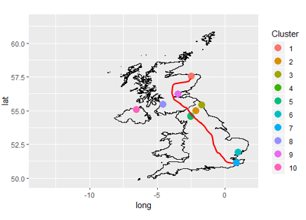
My objective is to be able to say that if I go from the point 1 to the point 7, my optimal route (red path) is close to the points 9, 3 and 5.
Maybe there is a package to make it easier or something like that. I have seen something about google maps but I couldn’t create a good code to implement it.
If anyone can help me I will be very grateful.