Hi,
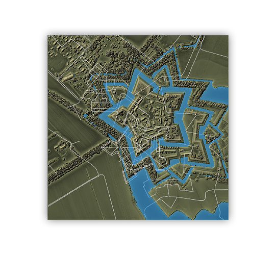
I am having an error when adding Open Street Map data do a rayshader map.
The error is that the overlapping of openstreetmap data is shifted. You may see the result in the image that I am appending.
The code is reproducible, and the data may be downloaded in the link showed in the code.
# based on gist: https://gist.github.com/norwegianblueparrot/b9d5d48f2d591d78a14320bf17459cc5

library("here")
library("sf")
library("rgl")
library("raster")
library("rayshader")
library("osmdata")
library("tidyverse")

## ----load_elevation_data---------------------------------------------------------------
# set this path to wherever you've saved the elevation data - it can be downloaded from
# https://download.pdok.nl/rws/ahn3/v1_0/05m_dsm/R_13DN2.ZIP

elevation_data <- here::here("data/elevation_data/bourtange")

# this data can be downloaded from
elevation_file <- elevation_data %>%
  file.path("R_13DN2.TIF")

elevation_raster <- elevation_file %>%
  raster::raster()

raster_crs <- elevation_raster %>%
  raster::crs()

## ----zoom_to_fortress---------------------

xmin <- 7.1869551422
xmax <- 7.1971968768
ymin <- 53.0042753099
ymax <- 53.0105807242

cropped_extent <- raster::extent(c(xmin, xmax, ymin, ymax)) %>%
  sf::st_bbox(crs = 4326) %>%
  sf::st_as_sfc() %>%
  sf::st_transform(crs = raster_crs) %>%
  sf::st_bbox() %>%
  raster::extent()

cropped_raster <- elevation_raster %>%
  raster::crop(y = cropped_extent)

plot(cropped_raster)

## ----scale_matrix----------------------
scaling_factor <- 2 # set > 1 to reduce size of matrix

raster_matrix <- cropped_raster %>%
  rayshader::raster_to_matrix(verbose = FALSE) %>%
  rayshader::resize_matrix(scale = 1 / scaling_factor)

# set missing values to -1 (assume this is water)
raster_matrix[is.na(raster_matrix)] <- -1

## ----calculate_zscale---------------------------------------------------------
estimated_zscale <- 0.5


## ----build_base_map-----------------------------------------------------------
base_map <- raster_matrix %>%
  rayshader::height_shade() %>%
  rayshader::add_overlay(rayshader::sphere_shade(raster_matrix, colorintensity = 5),
                         alphalayer = 0.5)  %>%
  rayshader::add_overlay(
    rayshader::sphere_shade(raster_matrix,
                            texture = "desert",
                            colorintensity = 5),
    alphalayer = 0.5
  ) %>%
  rayshader::add_shadow(rayshader::lamb_shade(raster_matrix), 0) %>%
  rayshader::add_shadow(rayshader::ambient_shade(raster_matrix), 0) %>%
  rayshader::add_shadow(
    rayshader::texture_shade(
      raster_matrix,
      detail = 8 / 10,
      contrast = 9,
      brightness = 11
    ),
    0.1
  )

## ----get_osm_overlays---------------------------------------------------------

bbox_long_lat <- sf::st_bbox(cropped_raster) %>%
  sf::st_as_sfc() %>%
  sf::st_transform(crs = 4326) %>%
  sf::st_bbox()

# get highways
bourtange_footways <- osmdata::opq(bbox_long_lat) %>%
  osmdata::add_osm_feature("highway") %>%
  osmdata::osmdata_sf()

footway_geom <- bourtange_footways$osm_lines %>%
  sf::st_transform(crs = raster_crs)

footway_overlay <- footway_geom %>%
  rayshader::generate_line_overlay(
    extent = cropped_extent,
    heightmap = raster_matrix,
    color = "gainsboro",
    linewidth = 2
  )

## ----render_overhead_map-------------------------------------------------------
base_map %>%
  rayshader::add_overlay(overlay = footway_overlay, alphalayer = 0.95) %>%
  rayshader::plot_3d(
    raster_matrix,
    water = TRUE,
    watercolor = "dodgerblue",
    windowsize = c(1200, 1200),
    zscale = estimated_zscale
  )

rayshader::render_camera(theta = 0, phi = 89.999, zoom = 0.75)
rayshader::render_snapshot()
Could you please help me find what is wrong?
Thank you,
Luis
