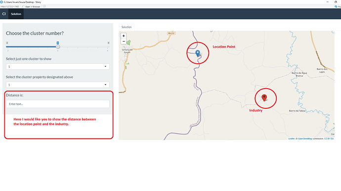
Friends, could you help me to insert the distance between coordinates in my shiny. Basically my shiny has a sliderInput that corresponds to the desired number of clusters, followed by an option of which cluster he wants to see on the map, and the second option which industry of the selected cluster he wants to see. So far it is working properly. Note that on the map there is always a location point and an industry, because for the generation of the map I am joining database df with database df1. However, I would like to add another feature, which is to calculate the distance between this location point and the industry. I inserted an attached image to better illustrate my idea. The distance calculation formula that I believe is the one I inserted below too, I just need help for shiny to display the distance in the textInput (Filter3) that I made. If not to be textInput it can be another way too. So, whenever he selects a cluster and the industry, I intend to show the distance between them too. The executable code is below.
library(shiny)
library(ggplot2)
library(rdist)
library(geosphere)
library(shinythemes)
library(leaflet)


function.cl<-function(df,k,Filter1,Filter2,Filter3){

  df<-structure(list(Industries = c(1,2,3,4,5,6),
                     Latitude = c(-23.8, -23.8, -23.9, -23.7, -23.7,-23.7),
                     Longitude = c(-49.5, -49.6, -49.7, -49.8, -49.6,-49.9),
                     Waste = c(526, 350, 526, 469, 534, 346)), class = "data.frame", row.names = c(NA, -6L))

  #clusters
  coordinates<-df[c("Latitude","Longitude")]
  d<-as.dist(distm(coordinates[,2:1]))
  fit.average<-hclust(d,method="average")
  clusters<-cutree(fit.average, k)
  nclusters<-matrix(table(clusters))
  df$cluster <- clusters

  #Localization
  center_mass<-matrix(nrow=k,ncol=2)
  for(i in 1:k){
    center_mass[i,]<-c(weighted.mean(subset(df,cluster==i)$Latitude,subset(df,cluster==i)$Waste),
                       weighted.mean(subset(df,cluster==i)$Longitude,subset(df,cluster==i)$Waste))}
  coordinates$cluster<-clusters
  center_mass<-cbind(center_mass,matrix(c(1:k),ncol=1))

  #Coverage
  coverage<-matrix(nrow=k,ncol=1)
  for(i in 1:k){
    aux_dist<-distm(rbind(subset(coordinates,cluster==i),center_mass[i,])[,2:1])
    coverage[i,]<-max(aux_dist[nclusters[i,1]+1,])}
  coverage<-cbind(coverage,matrix(c(1:k),ncol=1))
  colnames(coverage)<-c("Coverage_meters","cluster")

  #Sum of Waste from clusters
  sum_waste<-matrix(nrow=k,ncol=1)
  for(i in 1:k){
    sum_waste[i,]<-sum(subset(df,cluster==i)["Waste"])
  }
  sum_waste<-cbind(sum_waste,matrix(c(1:k),ncol=1))
  colnames(sum_waste)<-c("Potential_Waste_m3","cluster")

  #Tables to join information above and generate df1
  data_table <- Reduce(merge, list(df, coverage,sum_waste))
  data_table <- data_table[order(data_table$cluster, as.numeric(data_table$Industries)),]
  data_table_1 <- aggregate(. ~ cluster + Coverage_meters + Potential_Waste_m3, data_table[,c(1,5,6,7)], toString)
  df1<-as.data.frame(center_mass)
  colnames(df1) <-c("Latitude", "Longitude", "cluster")

  #specific cluster and specific propertie
  df_spec_clust <- df1[df1$cluster == Filter1,]
  df_spec_prop<-df[df$Industries==Filter2,]


  #Color and Icon for map
  ai_colors <-c("red","gray","blue","orange","green","beige","darkgreen","lightgreen", "lightred", "darkblue","lightblue",
                "purple","darkpurple","pink", "cadetblue","white","darkred", "lightgray","black")
  clust_colors <- ai_colors[df$cluster]
  icons <- awesomeIcons(
    icon = 'ios-close',
    iconColor = 'black',
    library = 'ion',
    markerColor =  clust_colors)

  leafIcons <- icons(
    iconUrl = ifelse(df1$Industries,
                     "https://image.flaticon.com/icons/svg/542/542461.svg"
    ),
    iconWidth = 45, iconHeight = 40,
    iconAnchorX = 25, iconAnchorY = 12)
  html_legend <- "<img src='https://image.flaticon.com/icons/svg/542/542461.svg'>"

  # Map for specific cluster and propertie
  if(nrow(df_spec_clust)>0){
    clust_colors <- ai_colors[df_spec_clust$cluster]
    icons <- awesomeIcons(
      icon = 'ios-close',
      iconColor = 'black',
      library = 'ion',
      markerColor =  clust_colors)

  m1<-leaflet(df_spec_clust) %>% addTiles() %>%
    addMarkers(~Longitude, ~Latitude, icon = leafIcons) %>%
    addAwesomeMarkers(leaflet(df_spec_prop) %>% addTiles(), lat=~df_spec_prop$Latitude, lng = ~df_spec_prop$Longitude, icon= icons,label=~cluster)#%>%
  plot1<-m1} else plot1 <- NULL


  return(list(
    "Plot1" = plot1,
    "Data" = data_table_1,
    "Data1" = data_table
  ))
}

ui <- bootstrapPage(
  navbarPage(theme = shinytheme("flatly"), collapsible = TRUE,
             "Cl",
             tabPanel("Solution",
                      sidebarLayout(
                        sidebarPanel(
                          tags$b(h3("Choose the cluster number?")),
                          sliderInput("Slider", h5(""),
                                      min = 2, max = 4, value = 3),
                          selectInput("Filter1", label = h4("Select just one cluster to show"),""),
                          selectInput("Filter2",label=h4("Select the cluster property designated above"),""),
                          textInput("Filter3", label = h4("Distance is:"), value = "Enter text..."),
                        ),
                        mainPanel(
                          tabsetPanel(
                            tabPanel("Solution", (leafletOutput("Leaf",width = "95%", height = "600"))))),
                      ))))

server <- function(input, output, session) {

  Modelcl<-reactive({
    function.cl(df,input$Slider,input$Filter1,input$Filter2,input$Filter3)
  })


  output$Leaf <- renderLeaflet({
    Modelcl()[[1]]
  })

  observeEvent(c(df,input$Slider),{
    abc <- req(Modelcl()$Data)
    updateSelectInput(session,'Filter1',
                      choices=c(sort(unique(abc$cluster))))
  })

  observeEvent(c(df,input$Slider,input$Filter1),{
    abc <- req(Modelcl()$Data1) %>% filter(cluster == as.numeric(input$Filter1))
    updateSelectInput(session,'Filter2',
                      choices = unique(abc$Industries))

})
}

shinyApp(ui = ui, server = server)
Code to calculate the distance between location point and industry
#Calculate the distance between location point and industry
Distance<-distm(rbind(subset(coordinates,cluster==i),center_mass[i,])[,2:1])
Thank you very much!
